 you are not logged in

![]()
![]()
![]()
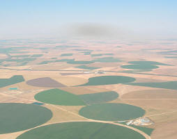
 Satellites help combat desertification and monitor degrading lands
In the context of the 10th Conference of the Parties to the UNCCD (UN Convention to Combat Desertification) ESA organised a side event on the monitoring and assessing of land degradation using satellite data. Remote Sensing from space is a powerful and cost-effective way of regularly monitoring the effect of programmes that combat desertification over large or hard-to-reach areas. The ESA-initiated DesertWatch project is developing a user-friendly information system based on Earth Observation technology to support national and local authorities in responding to the reporting obligations of the UNCCD in monitoring land degradation trends over time. In their findings presented at the conference, DesertWatch indicated that nearly half of the land in the south-eastern African country of Mozambique is degraded.
| Contact information | n/a |
|---|---|
| News type | Inbrief |
| File link |
http://www.esa.int/esaEO/SEM3Q1GURTG_index_0.html |
| Source of information | ESA |
| Keyword(s) | Desertification |
| Subject(s) | HYDRAULICS - HYDROLOGY , INFORMATION - COMPUTER SCIENCES , MEASUREMENTS AND INSTRUMENTATION , METHTODOLOGY - STATISTICS - DECISION AID , RISKS AND CLIMATOLOGY |
| Relation | http://www.semide.net/topics/WaterScarcity/fol083685 |
| Geographical coverage | n/a |
| News date | 17/11/2011 |
| Working language(s) | ENGLISH |
